Harrier Surveys

  • About Us
  • Services
    • Aerial Imagery
    • GIS/Mapping
    • Inspections
  • Our Difference
  • Our Projects
  • Team
  • News
  • Contact
 

Duncan6

Chip Pile

Lake

Eagle

Gravel Pit


Harrier Aerial Surveys

A fully licensed commercial unmanned aerial vehicle (UAV) remote sensing service provider

With our expertise in high-precision surveying, GIS, and remote sensing we offer accurate aerial imagery, digital elevation models and 3D measurements and calculations. Easily mobilized, data capture is performed quickly, accurately and at close proximity to the target while keeping operators and personnel out of harm’s way.


What We Do

Aerial Imagery

Harrier Aerial Surveys specializes in aerial imagery taken from unmanned aerial vehicles (UAV) commonly called drones.

High-resolution ortho-mosaics and oblique imagery lend a new perspective to your operation.

Nadir or straight down photographs allow us to stitch multiple images together to form one high-resolution ortho-mosaic of the target.

We capture oblique imagery when clients need visual inspections or vertical surface construction.

Mapping/GIS

Harrier Aerial Surveys has experience working with both GIS specialists needing raw data and industry professionals needing full geospatial solutions.

We provide the end results you need without the intermediate processing. We output prints, digital assets and a 3D data viewer.

We also perform geometric calculations including volume calculations, linear distancing, area calculations, change detections and topographic analytics.

Inspections

Harrier Aerial Surveys uses our multi-rotor UAV to get much closer to targets that are difficult or unsafe to get to in person.

Our Multi-rotor aircraft offers a stable platform for first person view of the object being inspected.  This offers the best vantage point for visual inspections of hard to reach places.

Setup time is faster than traditional methods and inspections can be completed without the need for costly operation shut downs.


Our Difference

When one of the largest and most modern single line kraft pulp mills in North America needed more accurate volume calculations, they chose Harrier Aerial Surveys.

We were able to drastically improve the accuracy of inventory calculations while also improving safety and efficiency. Call us today to see what we can do for your business.

Our Difference

Traditional Survey: 1,500 points in 8 hours
Aerial Survey: 15,000,000 points in 15 minutes


Harrier Aerial Surveys is fully covered with liability insurance and is certified by Transport Canada.

Transport Canada


Projects

See Our Team At Work:


The Harrier Team

placeholder

Peter LeCouffe
Operations Manager

Co-founder and operations manager, Peter keeps the business flowing. With his background in GIS and remote sensing Peter does most of the data handling and deliverable production.

Email: peter@harriersurveys.ca

Phone: (250)353-3300

placeholder

Robert Simmerling
Director

Co-founder and Professional Survey Engineer, Rob brings 30+ years of experience to each project. With hands on knowledge of major industrial operations Rob is key to the direction of the company based on client needs.

Email: robert@harriersurveys.ca

Phone: (250)354-9541

placeholder

Steve Johnson
Geomatics Technician

Geomatics Technician and field operative, Steve is an asset onsite for data collection and survey setup. No matter the project size or duration he is there to help the data acquisition go smoothly.

Email: steve@harriersurveys.ca

Phone: (250)354-0330

placeholder

Alexandre Landry
Geospatial Analyst

Geospatial analyst and field operative, Alex brings his background in GIS and remote sensing to support every step of our projects, including data collection, geoprocessing, spatial analysis and product delivery.

Email: alex@harriersurveys.ca

Phone: (250)353-3300


The Harrier Blog

Learn More About What We Do

Check out our New Video to See Harrier’s Team at Work.

June 21, 2018Comments are OFF
Earlier this spring, Harrier Aerial Surveys was called out to conduct a UAV survey of the landslide that covered Highway 3A just north of Castlegar, British Columbia. Check out our video to see how our team works to collect and deliver cutting edge information products to help authorities make important decisions when natural disasters strike.… Read More
Read More

Harrier Surveys Featured in the Latest Issue of Mining and Energy Magazine

January 8, 2018Comments are OFF
We always enjoy sharing our knowledge. A few months ago, Harrier’s operations manager, Peter LeCouffe was interviewed by Mining and Energy magazine to talk about our expertise and some of the cutting-edge work we do. Follow the link to Mining and Energy’s Winter 2017/2018 Issue and check out the Technology section to read the article.
Read More

Calculating Volumes Safely, Quickly and Accurately Using UAVs

January 3, 2018Comments are OFF
Setting new standards with UAVs Applications for commercial use of Unmanned Aerial Vehicles (UAVs) have surged in recent years and most industry sectors are becoming aware of the benefits that this technology can bring to them on many fronts. One significant application that UAV technology can be applied to is volume calculations. For example, when… Read More
Read More

What do Drones and Climate Change Have in Common?

May 10, 2016Comments are OFF
What do drones and climate change have in common? We recently found out.
Read More

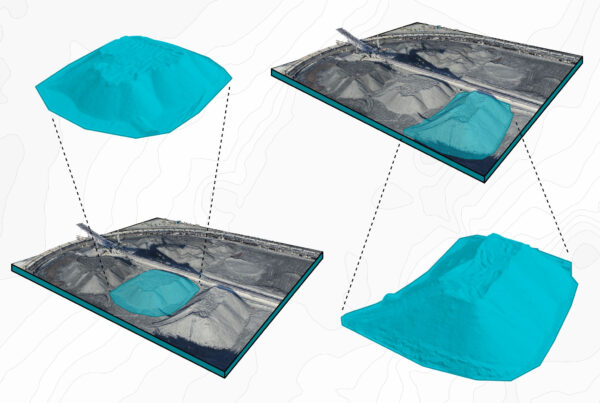
Why Use Unmanned Aerial Vehicles (UAV)?

May 19, 2016Comments are OFF
Unmanned Aerial Vehicles (UAV) provide efficient, cost-effective and accurate means to get the data you need.
Read More

GISday at Selkirk College Nov. 19th

March 30, 2016Comments are OFF
  We will be manning our booth at the Selkirk College GIS day conference on the 19th of November. Our very own Peter LeCouffe will also be presenting on drone technology, GIS applications of drones and his work with Selkirk College. Come check it out! You can register Here.
Read More

Helping with Public Awareness of Commercial Drones

March 30, 2016Comments are OFF
We were happy to sit down with Betsy Kline, a freelance reporter for Castlegar News, to shed some light on what’s going on up there. In the early stages of this industry we UAV professionals must foster the public awareness so that people realize we are not just hobbyists and flying by the seat of… Read More
Read More

Koocanusa Publications Interview

March 30, 2016Comments are OFF
We had a great time sharing the world of drones with Koocanusa Publications. Check out the two articles here: A kickin’ career flying drones Drones are ready for takeoff in the mining industry   Look out for the printed versions in both this month’s issue of Kootenay Business magazine and the next issue of Mining & Exploration magazine.
Read More
 

Contact Us

We're Easy to Reach:


Harrier Aerial Surveys

Box 192, 509A Lake St.
Nelson, British Columbia
Canada V1L 5P9

Email: info@harriersurveys.ca
Phone: (250)354-0330
Rob’s Cell: (250)354-9541
Peter’s Cell: (250)353-3300

Please feel free to give us a call or email. We would be happy to hear about your next project and answer any questions you may have.


Your Name (required)

Your Email (required)

Subject

Your Message


Copyright © 2018 Harrier Surveys